
Rever Long Term Review
Rever is one of the most popular motorcycle routing apps available today. I've been a Rever user since 2016. It moved from being entirely independent to being under the Comoto umbrella with Revzilla during that time. It has continued to be improved over that time. This long-term review under real-world conditions focuses on the current feature set.
We sometimes use affiliate links in our content. This won’t cost you anything extra, but if you purchase something from one of the links, we may earn some money for coffee. As an Amazon Associate, I earn from qualifying purchases.
REVER is a mobile app designed to help you track, plan, or navigate your ride. With the app, you can easily plan your route, view maps and directions, and track your distance using GPS technology. The app is an excellent tool for anyone who loves to ride and wants to keep track of their progress and distance.
However, it is also a website that allows riders to plan rides and review recorded tracks. A web app’s more significant screen real estate enables more details to be seen on screen at once and a more comprehensive view of the planned route.
The two environments seamlessly integrate so that anything created or edited on one is visible on the other. This advantage will become clearer later.
Planning
Many people are familiar with typical GPSs, where you can enter a destination & it will calculate the fastest way there. When you're driving to a store, this makes sense as it's a utility travel. On a motorcycle, we often aren't riding for utility but for pleasure. Finding a route to the destination that is fun for bikes is not necessarily the fastest one. Frequently, we look for twisty roads that get some lean on the bike. We often look for routes with incredible scenery, changes in elevation, and limited traffic.
Rever offers both a website and an app. While you can plan on both, I will use the website for the larger-screen real estate. Rever can be as straightforward or as advanced as you like with this. Rever also allows you to create a route with waypoints along the way. This is helpful if you have planned stops along the way or even for multi-day trips where you may put your accommodations for each night as the waypoint. You can drag the path to snap onto roads you'd instead take. This is one significant advantage over Google Maps. The odds are good if you see a river and a road beside it. It will make for a great motorcycle road, so being able to snap your route to these little diversions is excellent.
A-B Routing
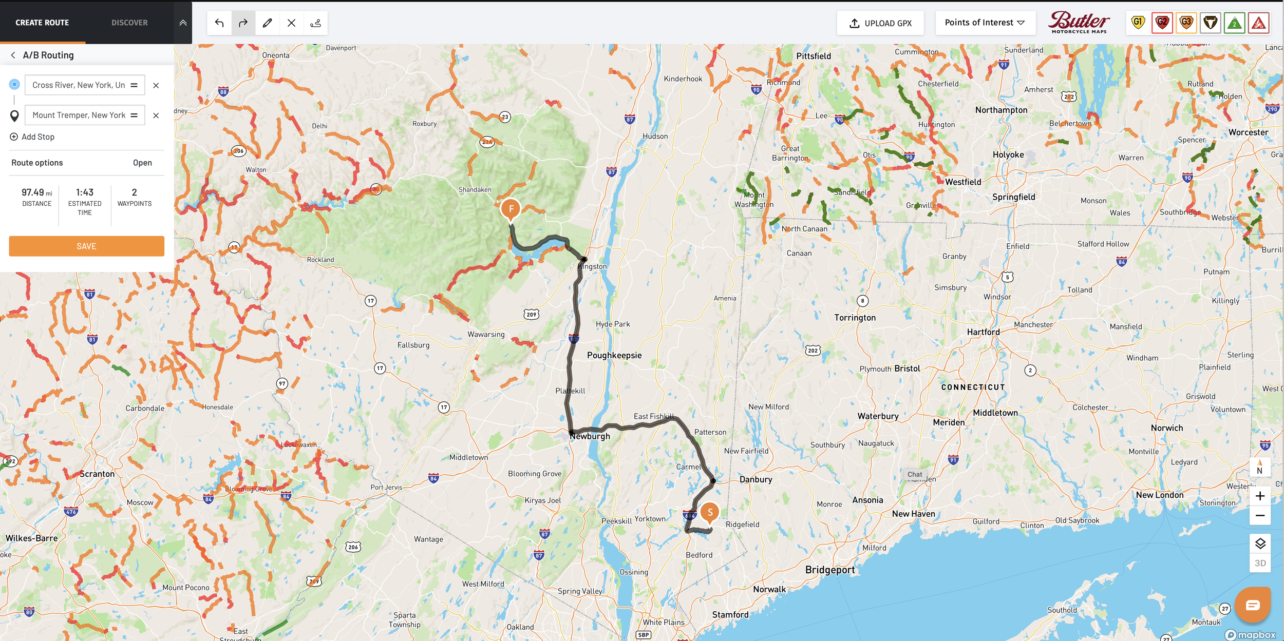
A-B routing will be instantly understandable if you are used to apps like Google Maps. This method focuses on the fastest route between two points, which can be a fantastic option if you need to get somewhere quickly.
Recording
Rever initially offered to record your route and planning, but there wasn't a navigation option. Recording is a great way to capture a route you did. You can use that as input for future routes, keeping track of the fun roads you hit. Rever has several challenges each year that recording can allow you to participate in. You can review these from the Participate option in the bottom nav bar.
One of the most popular is the Road Warrior challenge. This has been available for several years and runs from Dec 31 to Jan 1 to cover a full year of riding. Prizes are available both monthly and annually. While the top participants can be on the road daily, racking in as much as 80K miles, it’s a great way to see how you compare to your fellow riders. Revzilla published an article a few years ago that found most riders complete <1000 miles a year on the bikes. Top dogs in the Road Warrior challenge aren’t in that group, but sometimes, seeing that peers are out riding may inspire you to ride some more this year.
The biggest hurdle is forgetting to hit the record button on each ride. I’m personally guilty of that, though I do capture the vast majority. Looking at my miles in the Road Warrior challenge for 2023 in December, I recorded a little over 10K miles completed in 2023. I record every fuel tank refilling with an app called Fuelly that records the cost per gallon, miles on the odometer, and gallons filled. With that, I’ve recorded just over 11K miles, so I forget to record about 10% of the time.
Pro Version Features
Additional Routing Options
Twisty Roads
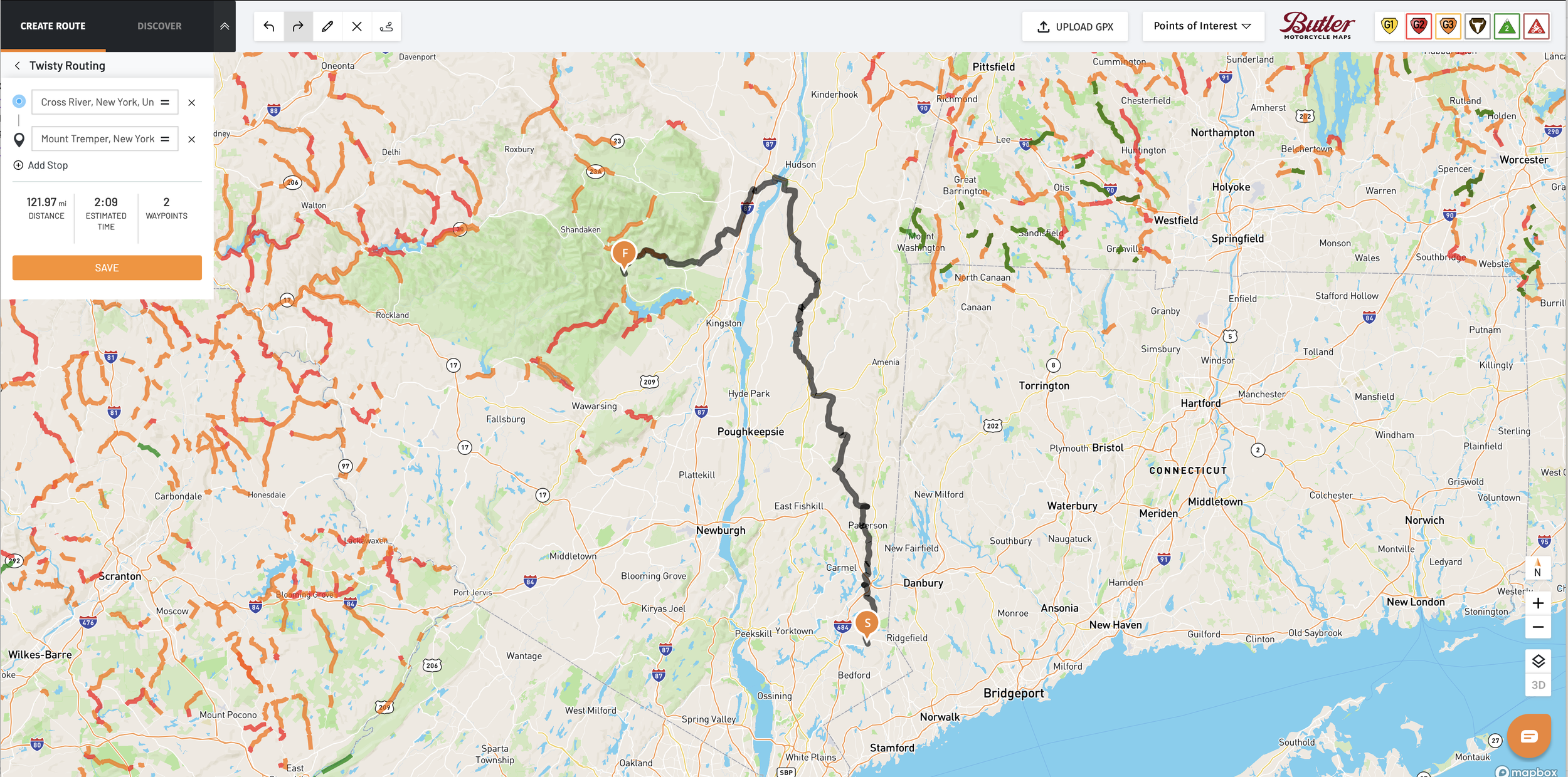
My favorite feature of Rever’s pro plan is the twisty roads routing. Think of this as almost the opposite of A-B planning. It focuses not on the fastest way between your waypoints but on the most fun way. When I plan a route, this is my go-to option.
Twisty roads will find the most curvy roads between your waypoints. These won’t be fast roads, but they will be nice ones. This provides a good baseline route for an unfamiliar area, and you can often find some good roads in more populated areas.
This is ideally paired with the Butler Maps Incredible Roads feature. Butler maps rate roads from G3 (Good) to G1 (Best). This combines twistiness, elevation changes, and scenery. If your ride takes you through an area with Butler roads, I often will drag the initial twisty route onto some of the Butler recommended roads. Some of these roads may be more out of my way than the default twisty roads picks, but as I drag the route onto them, it will still find the twisty roads between my selected road and the next waypoint.
Of course, being based in the Northeast means many of the roads near me aren’t even on the Butler ratings. I typically need to ride at least an hour via highway to get to the closest Butler roads as I’m still near the NYC metro area’s population center. So Twisty Roads finds good stuff locally.
ADVanced Off-Road Planner
The ADVanced Off-Road Planner is a recent addition focusing on the adventure motorcycling group. This is intended to plan out tracks that may not be on paved roads where turn-by-turn navigation exists. You set a starting waypoint and then add the next waypoint. It wants you to keep the waypoints no more than 5 miles from each other. It will then create a track that follows any navigable roads. While the other routing engines will avoid unpaved (dirt) roads, this engine is pleased to route on those.
It’s lovely to have this as another option. But, where I live, while there are a handful of dirt roads, they are nowhere near as plentiful as you’ll find out west where Rever is headquartered in Colorado. But if you are planning a trip and want to hit some dirt roads when you are there, this is another excellent tool.
Don’t worry if you don’t want to expose your expensive phone to the elements on an ADV ride, as you can export the track you created as a GPX file to use in other GPS units, like the Garmin Zumo XT.
Butler Maps

Butler Maps has produced paper maps for years. They are a popular resource for motorcyclists as they show great roads in an area on a 3-level rating scale. I have several of the paper maps and love using them for big-picture planning. But if you want to use a paper map while riding, you typically need to pull over to see it safely. This is what makes what Rever has added here so helpful.
Rever has digitally incorporated all of the Butler Maps into the app and website. You can enable the Butler Maps layers and see the highlighted roads directly on the screen.
GPX Import/Export
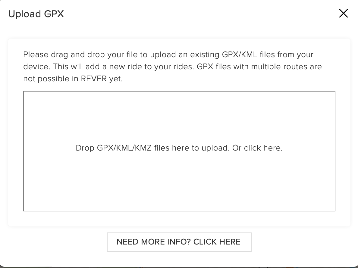
The export is an excellent option if you use a Garmin or TomTom GPS unit designed for motorcycles. You can craft a route in Rever and export it to use in your GPS of choice. It’s also helpful for sharing with riding buddies who may not have Rever.
Several of my bikes would look odd with a Garmin or a giant phone on the handlebars, so I use the Beeline. The GPX export from Rever means I can still craft and use a fantastic route on my Beeline. Of course, when I want to hit the dirt on my BMW R1200GS, I use my Garmin Zumo XT, and the GPX files created in Rever will quickly load onto that as well.
Download routes for offline use
One downside of an app-based nav system is that it often expects you to be connected to the internet to work with any routes you already have created online or even for the background map tiles. Much like Google Maps and Apple Maps, you can download the routes and maps for the area you are planning to travel through. So, if reception doesn’t support internet connections, you can still have your routes and maps with you.
See your route in 3D
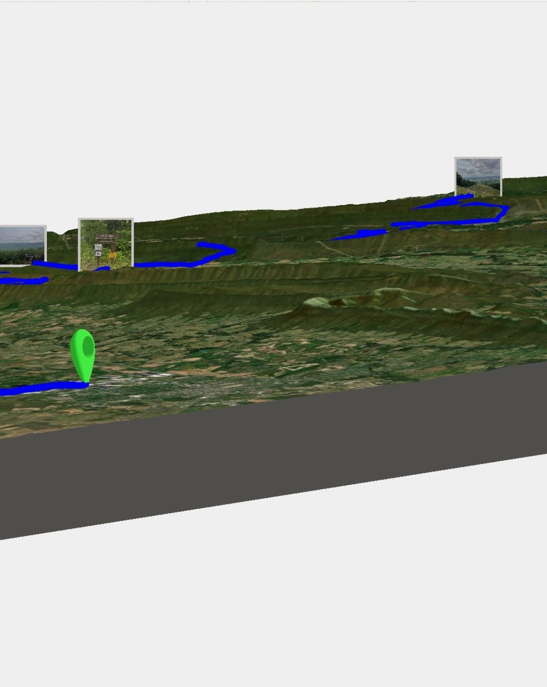
This is an innovative way to visualize your route. It works with both planned and recorded routes. It will generate the path onto a 3D space. You can either explore it by moving around to get a good view of the surrounding terrain or export a short video of the path animated through the terrain.
Navigation
The next several features are ones that arrived on Rever later but that I don’t personally use. I’m not a fan of using your phone’s screen for navigation. I’ve killed a phone’s camera using it for Rever in the past, and battery issues also have downsides.
Rever’s navigation capabilities and various layers are nice. I think there are two circumstances where using the navigation features may be worthwhile.
Using a weather & vibration hardened Android device
Using CarPlay or Android Auto with a native motorcycle screen
Using CarPlay or Android Auto with a wireless hardened screen
Some Android devices, like a dedicated nav unit from Garmin or TomTom, are hardened for outside use. This offers the ability to use apps without the issues of dust, vibration, and moisture resistance that most typical phones aren’t designed for. These aren’t cheap, and you may require an additional cell service to benefit fully from them. If you’re already in the Android ecosystem, one of these could be your regular device. Still, they are more bulky because of the additional hardening, so whether you choose to have them as your primary phone is a call for you to make.
CarPlay would be the other option. This would keep your phone away from dust, moisture, and vibration exposure on your handlebar while still benefiting from using the apps. Unfortunately, there are limited motorcycles that support this at present. Indian Motorcycles has it on their 2020 and newer Chieftain, Pursuit, Roadmaster & Challenger bikes with Ride Command. Honda also offers CarPlay on some of their models.
Finally, you can get a dedicated unit that provides CarPlay & Android Auto from something like Ottocast. This is the most universal option, allowing you to have CarPlay on any bike. But at this point, you are starting to compete with dedicated nav units like the Zumo, which will work without your phone, so is that worth it?
Weather Map Layers
While there are riders who are only fair-weather riders, many of us ride year-round in any weather. While we may be okay with getting wet, seeing where the rain is on a moving map can help us avoid it. This is where this feature from Rever comes in handy. Seeing the rain areas on the moving map allows you to avoid them on your ride.
Fuel, Restaurants, and other POIs
When you are out for a ride, seeing options for fuel, restaurants, rest stops, or other POIs can help you decide where to take a break.
Real-time weather alerts
Alongside the map layers for weather, this feature can alert you of changing weather conditions that may influence you. Some impending rain and feeling hungry is the opportune time to grab lunch at the restaurant you see on the map.
LiveRide
This allows you to see your friends position and share yours live on the Rever map. This can be helpful for a group ride to see where everyone is. It also may inspire you to get out on your bike when a friend is riding.
How I use Rever
Planning
Rever is my go-to option for planning a route. The ability to use twisty roads alongside Butler Maps is a killer combo, in my opinion and why I pony up for the Pro plan. I typically plan on the website, as the bigger screen makes it easier. I can leverage the POIs to plan fuel and food stops for longer trips.
Day rides that return to start
This is typically the most common route I do. While Rever can create a loop route that returns to the starting point, it is generally better to split it up for an outbound and return route. Often, I have a lunch spot or some other destination in mind as the midpoint. Depending on the available time for riding that day, I may use twisty roads leading to the midpoint and then do the fastest A-B routing to return. If I have available time for fun roads on the return, I try to create a route that doesn’t mirror the outbound for the return, so there are different roads.
Multi-day trips
There are two variations here: a base camp mode or travel day-to-day. Basecamp is good if you will be at a place for a few days and want some day rides from that spot.
Day-to-day travel is when I’m traveling long distances beyond one day of travel & want to plan the routes for each day. I’ll monitor the overall length and duration and add fuel or food stops for longer rides.
Recording
Even if I’m not following a pre-planned route, I use Rever. Each ride I do is recorded with Rever. I never have to wonder what that great road I found was as I have a record of it with Rever. When I finish a ride, I’ll add some notes to remind me of the ride’s highlights. Next time I create a route, I can refer to roads I’d captured before, incorporate the good ones into the route, and bypass the not-so-interesting parts. Another benefit is that Rever can track the miles and time you’ve ridden in a period. So I can see how much more or less riding I’m doing this week vs the last several weeks.
Sharing
One of the best features of Rever is the ability to share rides with others. This works both for planned rides and ridden (recorded) ones. If I’m doing a pre-planned ride with friends, I’ll often share the route via Rever with them in advance. As the Pro version also lets me export GPX files, I can share the GPX for those not using Rever already.
Each coffee ride done with Tank of Coffee has the route displayed within the page as recorded by Rever. This map embed is easy with Rever and allows readers to see the map & follow along on their own as needed.